Snow Hits Some Regions Hard While Others Barely Notice
Parts of southern and central British Columbia plunged into winter overnight. Heavy snowfall blanketed Interior mountain zones, leaving deep snowpack in key watersheds. But along the southwest edge including coastal and lowland areas snow remained scarce, creating a sharp contrast across the province.
Road-weather alerts have gone up in mountain corridors, as freeze-thaw cycles could create icy surfaces and avalanches in snow-heavy zones. Meanwhile, residents near sea level or on the coast saw almost no snow, leaving sidewalks and roads bare this morning.
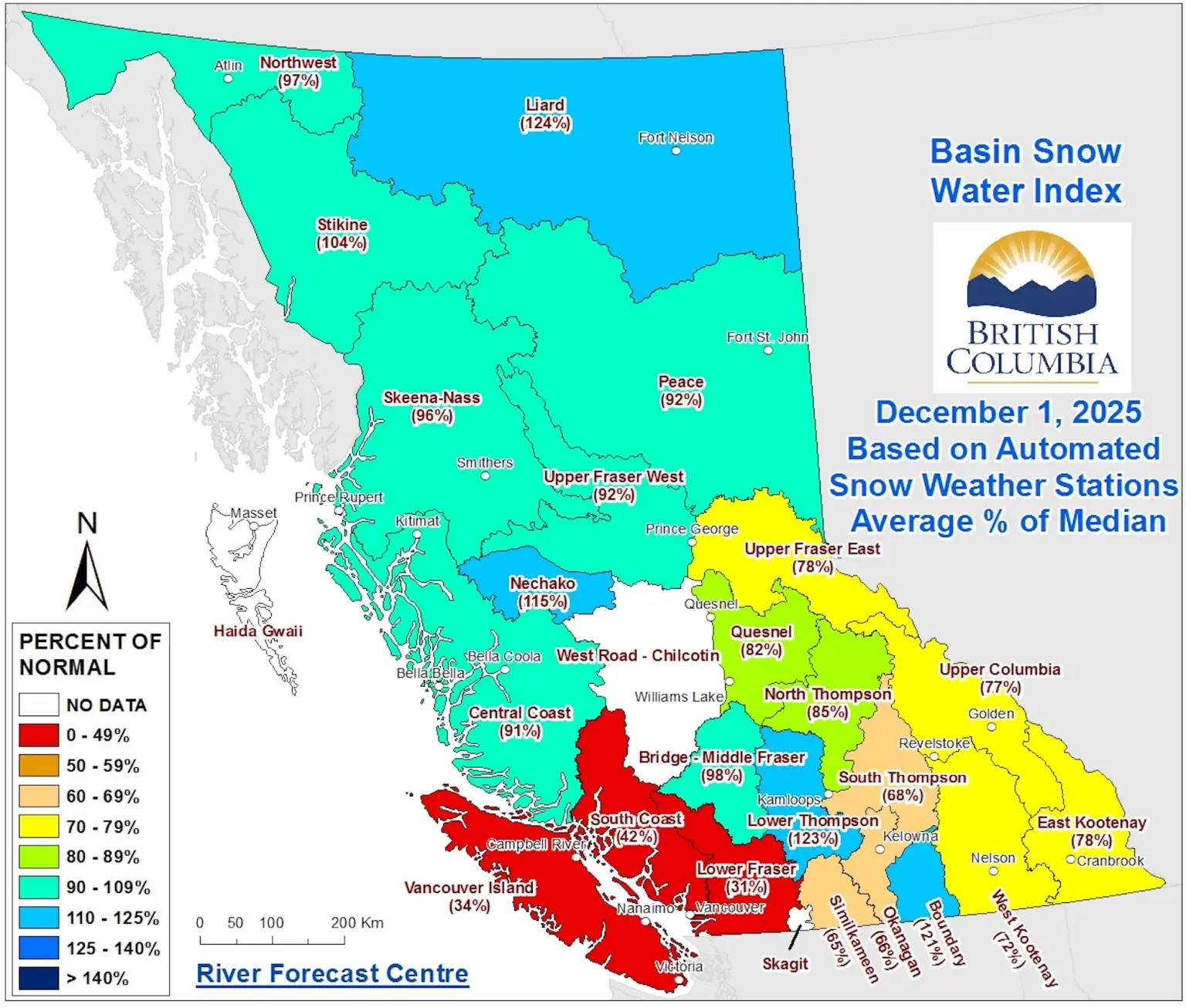
What the Data Show Snowpack Varies Widely
Recent bulletins from the provincial River Forecast Centre show that Interior basins especially South-Central zones are picking up strong snow accumulations, often reaching or exceeding seasonal norms.
By contrast, coastal and low-elevation basins continue to register well below normal snowpack. In some areas the snow cover remains minimal to none, even as storms dump snow higher in the mountains.
What It Means for Water Supply, Ski Season and Flood Risk
For Interior communities and ecosystems, the heavy snowpack improves the forecast for water resources. Snowmelt will feed rivers and reservoirs vital for drinking water, agriculture, and hydroelectric generation in coming months.
Snow-dependent industries such as skiing and winter tourism will likely benefit from solid snow at elevation. Ski resorts in the Interior could see strong conditions early in the season.
But the uneven snow distribution also carries risks. When temperatures rise, rapid snowmelt or combined rain-and-snow events could trigger flooding, even as coastal areas remain dry. As officials warn, shifting conditions from deep snow to spring thaw will require vigilance.
What Residents Should Watch For Now
- Drivers crossing mountain passes: expect snow, ice, and limited visibility. Use winter tires, slow down, and monitor conditions.
- Interior residents: check for flood warnings as snow melts. Prepare for possible surges in rivers and streams once spring arrives.
- Coastal and southwest residents: don’t assume winter is “backwards.” Low snowpack may lead to drier conditions and water-supply stress later in the season especially if rainfall remains below normal.
- Outdoor recreation enthusiasts: keep an eye on avalanche forecasts if heading into alpine terrain. Heavy snowpack + warm spells = increased avalanche risk.
In short
British Columbia is waking up to a winter of contrasts. Some regions sit under deep snow as the season begins, while others remain nearly snowless. The winter ahead promises to bring both opportunity and challenge from ski slopes and full reservoirs to flood risks and dry lowlands.
Stay updated instantly — follow us on Instagram | Facebook | X


